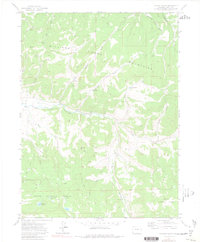
1971 Map of Hayden Gulch
USGS Topo · Published 1980About this map
The Williams Fork Mountains dominate this 1971 topographical study, an area defined by steep drainages and early industrial exploration within the Routt National Forest. The landscape is carved by the East Fork Williams Fork and its numerous tributaries, including Hayden Gulch, Berry Gulch, and Lone Gulch. Human activity is centered on water management and resource extraction, evidenced by several family-named water features such as Wyman Reservoir, Dillabaugh Res, and Maud Wise Res.
Find a feature on this map
36 named features on this map. Tap any name to fly to it.
Don’t see what you’re looking for? This feature index may not catch every label — zoom into the map to look around manually.
Map Details
Editions of this 1971 Hayden Gulch Map
3 editions found
Other maps of this area

1916 · Daton Peak
USGS Topo · 1:62,500

1920 · Daton Peak
USGS Topo · 1:62,500

1924 · Mt. Harris
USGS Topo · 1:48,000

1926 · Mount Harris
USGS Topo · 1:62,500

1954 · Craig
USGS Topo · 1:250,000

1957 · Craig
USGS Topo · 1:250,000

1958 · Craig
USGS Topo · 1:250,000

1960 · Craig
USGS Topo · 1:250,000

1962 · Craig
USGS Topo · 1:250,000

1964 · Craig
USGS Topo · 1:250,000