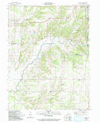
1959 Map of Hayden
USGS Topo · Published 1993About this map
The Baltimore and Ohio Railroad corridor serves as a primary east-west artery across this Jennings County landscape, connecting the community of Hayden to the western outskirts of North Vernon. The land is defined by the winding course of the Muscatatuck River and the Fork Vernon, which carve through the townships of Spencer, Center, and Lovett. This 1950s survey reveals a deeply rooted rural infrastructure of small country churches and family-named cemeteries, including Zion Church and the St. Catherines Cemetery.
Find a feature on this map
45 named features on this map. Tap any name to fly to it.
Don’t see what you’re looking for? This feature index may not catch every label — zoom into the map to look around manually.
Map Details
Editions of this 1959 Hayden Map
Other maps of this area

1942 · Columbus
USGS Topo · 1:125,000

1953 · Cincinnati
USGS Topo · 1:250,000

1956 · Volga
USGS Topo · 1:24,000

1956 · Deputy
USGS Topo · 1:24,000

1956 · Louisville
USGS Topo · 1:250,000

1957 · Cincinnati
USGS Topo · 1:250,000

1957 · Butlerville
USGS Topo · 1:24,000

1957 · Azalia
USGS Topo · 1:24,000

1957 · North Vernon
USGS Topo · 1:24,000
1959 · Vernon
USGS Topo · 1:24,000