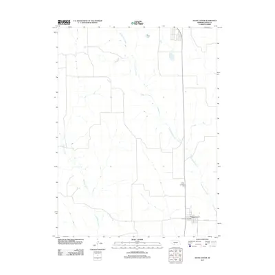
2011 Map of Hayes Center
USGS Topo · Published 2011About this map
Hayes Center serves as the focal point of this southwestern Nebraska landscape, situated near the intersection of Road 1470 and Road 1455. The settlement is anchored by local infrastructure including the Hayes Center Post Office, reflecting its role as a regional hub for the surrounding plains. The terrain is defined by the winding paths of Little Blackwood Creek and Blackwood Creek, which carve drainage patterns across the high prairie. Located north of the main townsite, the Hayes Center Cemetery provides a significant touchstone for genealogical research in Hayes County. This 2011 survey illustrates the modern configuration of the rural grid system and the enduring placement of community landmarks in a sparsely populated agricultural environment.
Find a feature on this map
7 named features on this map. Tap any name to fly to it.
Don’t see what you’re looking for? This feature index may not catch every label — zoom into the map to look around manually.
Map Details
Editions of this 2011 Hayes Center Map
This is the sole edition of this map. No revisions or reprints were ever made.
Other maps of this area

1954 · McCook
USGS Topo · 1:250,000

1957 · McCook
USGS Topo · 1:250,000

1958 · McCook
USGS Topo · 1:250,000

1973 · Suttlers Canyon East
USGS Topo · 1:24,000

1973 · Suttlers Canyon West
USGS Topo · 1:24,000

1973 · Hayes Center NW
USGS Topo · 1:24,000
1973 · Burger Canyon West
USGS Topo · 1:24,000

1974 · Hamlet
USGS Topo · 1:24,000

1974 · Hayes Center
USGS Topo · 1:24,000
1974 · Palisade NE
USGS Topo · 1:24,000