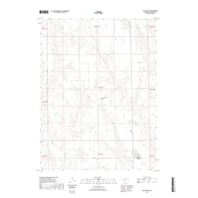
2017 Map of Hayes Center
USGS Topo · Published 2017About this map
Hayes Center serves as the focal point of this plains landscape in Hayes County, defined by a grid of rural roads and the undulating drainage of Blackwood Cr and Little Blackwood Cr. The town layout is clearly delineated by streets such as Francis St, Troth St, and Hamilton Ave, reflecting a settled agricultural community in the early 21st century. To the north, Government Canyon breaks the prairie floor, providing a distinctive geographical landmark amidst the surrounding section lines. Genealogy researchers will find the Hayes Center Cem positioned just north of the village, a key site for tracing local heritage. The map also records the path of Old Hwy 17 as it skirts the southern reaches of the Blackwood valley, highlighting the persistent importance of these established transit corridors in western Nebraska.
Find a feature on this map
26 named features on this map. Tap any name to fly to it.
Don’t see what you’re looking for? This feature index may not catch every label — zoom into the map to look around manually.
Map Details
Editions of this 2017 Hayes Center Map
This is the sole edition of this map. No revisions or reprints were ever made.
Other maps of this area

1954 · McCook
USGS Topo · 1:250,000

1957 · McCook
USGS Topo · 1:250,000

1958 · McCook
USGS Topo · 1:250,000

1973 · Suttlers Canyon East
USGS Topo · 1:24,000

1973 · Suttlers Canyon West
USGS Topo · 1:24,000

1973 · Hayes Center NW
USGS Topo · 1:24,000
1973 · Burger Canyon West
USGS Topo · 1:24,000

1974 · Hamlet
USGS Topo · 1:24,000

1974 · Hayes Center
USGS Topo · 1:24,000
1974 · Palisade NE
USGS Topo · 1:24,000