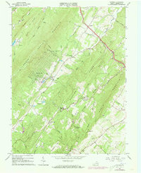
1965 Map of Hayfield
USGS Topo · Published 1973About this map
Great North Mountain and the ridgelines of the Shenandoah Valley dominate this 1965 survey of Frederick County, Virginia. The settlement of Hayfield serves as a local hub along the Winchester and Western railroad corridor, while smaller communities like Mt Williams and the developing Shawnee-Land occupy the lower slopes. The landscape is defined by its gaps and grades, including Fawcett Gap and the Wardensville Grade, which provided essential passage through the steep terrain of Hunting Ridge and Little North Mountain.
Find a feature on this map
54 named features on this map. Tap any name to fly to it.
Don’t see what you’re looking for? This feature index may not catch every label — zoom into the map to look around manually.
Map Details
Editions of this 1965 Hayfield Map
3 editions found
Other maps of this area

1894 · Winchester
USGS Topo · 1:125,000

1914 · Gerrardstown
USGS Topo · 1:48,000

1916 · Gerrardstown
USGS Topo · 1:62,500

1916 · Capon Bridge
USGS Topo · 1:62,500

1923 · Middletown
USGS Topo · 1:62,500

1923 · Capon Bridge
USGS Topo · 1:62,500

1937 · Capon Bridge
USGS Topo · 1:48,000

1937 · Gerrardstown
USGS Topo · 1:48,000

1937 · Middletown
USGS Topo · 1:48,000

1938 · Winchester
USGS Topo · 1:48,000