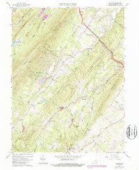
1965 Map of Hayfield
USGS Topo · Published 1987About this map
Great North Mountain and North Mountain dominate this part of Frederick County, forming parallel ridges that define the valley corridors of the northern Shenandoah region. The agricultural and timbered landscape of the mid-1960s is evidenced by the numerous mountain gaps and hollows, such as Clowser Gap and Yellow Spring Hollow, which served as traditional passage points for local commerce. The village of Hayfield serves as a central hub, while smaller residential developments like Shawnee-Land and High View Manor mark the mid-century growth of the area. Transportation infrastructure is anchored by the Winchester and Western railroad, which follows the contours of the valley floor. The map is a significant resource for those tracing local heritage, documenting numerous rural congregations like Mt Olive Ch and St Pauls Ch, alongside family-named landmarks such as Wisecarver Cem and Beans Hill.
Find a feature on this map
56 named features on this map. Tap any name to fly to it.
Don’t see what you’re looking for? This feature index may not catch every label — zoom into the map to look around manually.
Map Details
Editions of this 1965 Hayfield Map
3 editions found
Other maps of this area

1894 · Winchester
USGS Topo · 1:125,000

1914 · Gerrardstown
USGS Topo · 1:48,000

1916 · Gerrardstown
USGS Topo · 1:62,500

1916 · Capon Bridge
USGS Topo · 1:62,500

1923 · Middletown
USGS Topo · 1:62,500

1923 · Capon Bridge
USGS Topo · 1:62,500

1937 · Capon Bridge
USGS Topo · 1:48,000

1937 · Gerrardstown
USGS Topo · 1:48,000

1937 · Middletown
USGS Topo · 1:48,000

1938 · Winchester
USGS Topo · 1:48,000