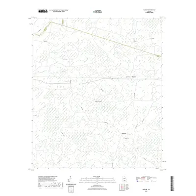
2020 Map of Haylow
USGS Topo · Published 2020About this map
The settlement of Haylow and the surrounding woodlands of Echols County define this modern topographic landscape near the Georgia-Florida border. The area is characterized by a high density of "bays"—shallow, marshy depressions typical of the coastal plain—including Boggy Bay, Bee Bay, and Whitehead Bay. These wetlands, along with slow-moving watercourses like Cow Cr and Toms Cr, dictate the placement of local thoroughfares such as Bamburg Rd and Withers Rd. Small rural clusters like Bamburg and Withers anchor the road network, while family-named landmarks such as Bexley Bay and Simmons Bay suggest long-standing local ties to the land. The geography is largely defined by the intersection of these hydrologic features with county boundaries, where Echols County meets Lanier and Clinch counties in a mosaic of timberland and wetland basins.
Find a feature on this map
38 named features on this map. Tap any name to fly to it.
Don’t see what you’re looking for? This feature index may not catch every label — zoom into the map to look around manually.
Map Details
Editions of this 2020 Haylow Map
This is the sole edition of this map. No revisions or reprints were ever made.
Other maps of this area

1954 · Valdosta
USGS Topo · 1:250,000

1958 · Valdosta
USGS Topo · 1:250,000

1959 · Valdosta
USGS Topo · 1:250,000

1968 · Naylor
USGS Topo · 1:24,000

1971 · Thelma
USGS Topo · 1:24,000

1971 · Howell
USGS Topo · 1:24,000

1971 · Du Pont
USGS Topo · 1:24,000

1971 · Stockton
USGS Topo · 1:24,000

1971 · Tarver
USGS Topo · 1:24,000
1971 · Pineland
USGS Topo · 1:24,000