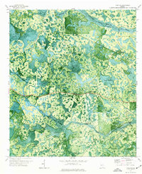
1971 Map of Pineland
USGS Topo · Published 1976About this map
Pineland serves as the central settlement point in this topographic study of the south Georgia lowlands near the Clinch Co Echols Co boundary. The landscape is defined by an intricate network of wetlands and shallow basins, including Flag Pond, Savannah Bay, and the uniquely named Gopher Lope. These watery features are interconnected by Suwannoochee Creek and Toms Creek, where historical crossings like Brown Ford and Martha Johns Ford provided vital passage through the marshy terrain. The presence of an Old Railroad Grade running through the northeastern sector suggests a history of timber extraction or transport that once moved through this densely wooded region. From the Lookout Tower near the county line to the unusual geological feature of Georgia Sink, the map captures a pocket of the Deep South where drainage patterns and local hammocks, such as Martin Hammock, dictated the placement of roads and homesteads.
Find a feature on this map
21 named features on this map. Tap any name to fly to it.
Don’t see what you’re looking for? This feature index may not catch every label — zoom into the map to look around manually.
Map Details
Editions of this 1971 Pineland Map
This is the sole edition of this map. No revisions or reprints were ever made.
Other maps of this area

1954 · Valdosta
USGS Topo · 1:250,000

1955 · Jasper
USGS Topo · 1:24,000

1955 · Cypress Creek
USGS Topo · 1:24,000

1955 · Fargo SW
USGS Topo · 1:24,000

1958 · Valdosta
USGS Topo · 1:250,000

1959 · Valdosta
USGS Topo · 1:250,000

1968 · Needmore
USGS Topo · 1:24,000

1968 · Headlight
USGS Topo · 1:24,000

1971 · Thelma
USGS Topo · 1:24,000

1971 · Tarver
USGS Topo · 1:24,000