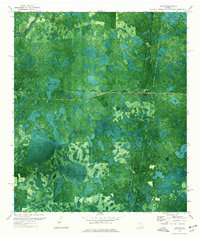
1971 Map of Haylow
USGS Topo · Published 1976About this map
Georgia Southern and Florida and the Seaboard Coast Line railroads form the industrial backbone of this South Georgia landscape, where the settlements of Haylow, Withers, and Bamburg are positioned along these rail corridors. The terrain is characterized by a high density of shallow, swampy depressions locally termed bays, including the expansive Boggy Bay and Sand Hill Bay. This orthophotomap provides a rare hybrid view, combining traditional topographic contouring with aerial imagery to reveal the complex patterns of pine stands and wetlands typical of the region.
Find a feature on this map
20 named features on this map. Tap any name to fly to it.
Don’t see what you’re looking for? This feature index may not catch every label — zoom into the map to look around manually.
Map Details
Editions of this 1971 Haylow Map
This is the sole edition of this map. No revisions or reprints were ever made.
Other maps of this area

1954 · Valdosta
USGS Topo · 1:250,000

1958 · Valdosta
USGS Topo · 1:250,000

1959 · Valdosta
USGS Topo · 1:250,000

1968 · Naylor
USGS Topo · 1:24,000

1971 · Thelma
USGS Topo · 1:24,000

1971 · Howell
USGS Topo · 1:24,000

1971 · Du Pont
USGS Topo · 1:24,000

1971 · Stockton
USGS Topo · 1:24,000

1971 · Tarver
USGS Topo · 1:24,000
1971 · Pineland
USGS Topo · 1:24,000