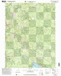
2000 Map of Haypress Valley
USGS Topo · Published 2003About this map
Bassetts serves as a small junction point in this high Sierra landscape, situated near the confluence of the North Yuba River and Salmon Creek. The terrain is defined by steep ridges and deep valleys, including Sardine Ridge and Williams Ridge, which dominate the northern and central portions of the map. This area of the Tahoe National Forest shows a complex history of land use, where mining legacies at the Pride Mine, Kentucky Mine, and William Tell Mine exist alongside mid-century water management projects like Milton Reservoir and the larger Jackson Meadows Reservoir to the south.
Find a feature on this map
58 named features on this map. Tap any name to fly to it.
Don’t see what you’re looking for? This feature index may not catch every label — zoom into the map to look around manually.
Map Details
Editions of this 2000 Haypress Valley Map
This is the sole edition of this map. No revisions or reprints were ever made.
Other maps of this area

1890 · Sierraville
USGS Topo · 1:125,000

1891 · Downieville
USGS Topo · 1:125,000

1891 · Colfax
USGS Topo · 1:125,000

1891 · Truckee
USGS Topo · 1:125,000

1892 · Sierraville
USGS Topo · 1:125,000

1892 · Colfax
USGS Topo · 1:125,000

1893 · Truckee
USGS Topo · 1:125,000

1893 · Downieville
USGS Topo · 1:125,000

1894 · Colfax
USGS Topo · 1:125,000

1894 · Sierraville
USGS Topo · 1:125,000