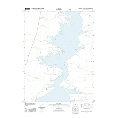
2012 Map of Haystack Buttes South
USGS Topo · Published 2012About this map
Flaming Gorge Reservoir dominates the eastern half of this Sweetwater County landscape, defined by its intricate, many-fingered shoreline where water meets the arid high-desert terrain. In the western reaches, the topography is shaped by seasonal watercourses like Anvil Wash and Anvil Draw Rd, which traverse the open country toward the reservoir. The United States Forest Service maintains a significant presence here, with a network of access routes including US Forest Service Road 83 and Usfs Rd 152 that facilitate movement through the brush and tablelands. To the east, Middle Marsh Cr feeds into the main body of the reservoir, while Wildhorse Draw marks a prominent geographic break in the terrain. This map serves as a clear record of federal land management and recreational infrastructure in Wyoming during the early twenty-first century.
Find a feature on this map
10 named features on this map. Tap any name to fly to it.
Don’t see what you’re looking for? This feature index may not catch every label — zoom into the map to look around manually.
Map Details
Editions of this 2012 Haystack Buttes South Map
This is the sole edition of this map. No revisions or reprints were ever made.
Other maps of this area

1885 · Ashley
USGS Topo · 1:250,000

1906 · Marsh Peak
USGS Topo · 1:125,000

1908 · Marsh Peak
USGS Topo · 1:125,000

1952 · Dutch John Mtn
USGS Topo · 1:24,000

1952 · Flaming Gorge
USGS Topo · 1:24,000

1954 · Vernal
USGS Topo · 1:250,000

1954 · Rock Springs
USGS Topo · 1:250,000

1957 · Currant Creek Ranch
USGS Topo · 1:62,500

1958 · Vernal
USGS Topo · 1:250,000

1958 · Rock Springs
USGS Topo · 1:250,000