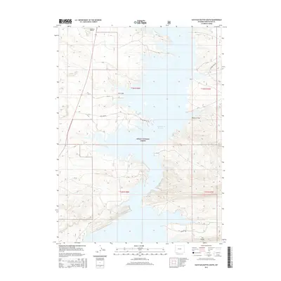
2015 Map of Haystack Buttes South
USGS Topo · Published 2015About this map
Flaming Gorge Reservoir dominates this high-desert landscape in southern Wyoming, where deep canyons and complex water inlets carve through the terrain. The waters of the reservoir fill the lower elevations of the Green River valley, bounded to the south by the high ridges of The Glades. Within the Ashley National Forest, the topography is defined by significant drainage systems such as Anvil Wash and Wildhorse Draw, which reflect the erosive power of the region's geography. Historically significant landmarks such as Haystack Buttes overlook the reservoir, while a network of rural routes including Anvil Draw Rd and Flaming Gorge Rd provide access to the backcountry. This map serves as a modern record of the intersection between managed federal lands and the massive water reclamation projects that shaped this portion of Sweetwater County.
Find a feature on this map
13 named features on this map. Tap any name to fly to it.
Don’t see what you’re looking for? This feature index may not catch every label — zoom into the map to look around manually.
Map Details
Editions of this 2015 Haystack Buttes South Map
This is the sole edition of this map. No revisions or reprints were ever made.
Other maps of this area

1885 · Ashley
USGS Topo · 1:250,000

1906 · Marsh Peak
USGS Topo · 1:125,000

1908 · Marsh Peak
USGS Topo · 1:125,000

1952 · Dutch John Mtn
USGS Topo · 1:24,000

1952 · Flaming Gorge
USGS Topo · 1:24,000

1954 · Vernal
USGS Topo · 1:250,000

1954 · Rock Springs
USGS Topo · 1:250,000

1957 · Currant Creek Ranch
USGS Topo · 1:62,500

1958 · Vernal
USGS Topo · 1:250,000

1958 · Rock Springs
USGS Topo · 1:250,000