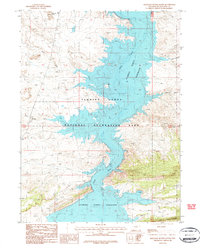
1987 Map of Haystack Buttes South
USGS Topo · Published 1987About this map
Flaming Gorge Reservoir dominates this landscape, filling the deep canyons of the Green River as it passes through the Flaming Gorge National Recreation Area. The map records a dramatic meeting of water and desert in the late 1980s, where the high-water line of the reservoir contrasts with the arid breaks of The Glades and the prominent Haystack Buttes to the north. Evidence of resource management and industrial infrastructure appears throughout the terrain, from a isolated Pumping Station near the river to a documented Drill Hole in the western uplands. Seasonal drainage patterns are clearly marked by features such as Anuit Wash, Twin Buttes Draw, and Wildhorse Draw, providing a precise look at the hydrology and land use of Sweetwater County before the close of the century.
Find a feature on this map
13 named features on this map. Tap any name to fly to it.
Don’t see what you’re looking for? This feature index may not catch every label — zoom into the map to look around manually.
Map Details
Editions of this 1987 Haystack Buttes South Map
This is the sole edition of this map. No revisions or reprints were ever made.
Other maps of this area

1885 · Ashley
USGS Topo · 1:250,000

1906 · Marsh Peak
USGS Topo · 1:125,000

1908 · Marsh Peak
USGS Topo · 1:125,000

1952 · Dutch John Mtn
USGS Topo · 1:24,000

1952 · Flaming Gorge
USGS Topo · 1:24,000

1954 · Vernal
USGS Topo · 1:250,000

1954 · Rock Springs
USGS Topo · 1:250,000

1957 · Currant Creek Ranch
USGS Topo · 1:62,500

1958 · Vernal
USGS Topo · 1:250,000

1958 · Rock Springs
USGS Topo · 1:250,000