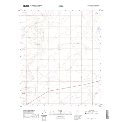
2023 Map of Haystack Mountain
USGS Topo · Published 2023About this map
Haystack Mountain and Railroad Mountain dominate this high-desert landscape in Chaves County, where dry drainage networks and isolated water sources define the terrain. The map traces the winding course of Sixmile Draw and Sand Creek, highlighting the critical nature of water in this arid environment through features like Leslie Spring and the ephemeral Samples Lake. The rectilinear grid of the Public Land Survey System is overlaid by a sparse network of county roads including Dunken Rd and Olive Rd, which provide access to this open range. This 2023 edition uses modern survey data to preserve the names of geographic landmarks and grazing-era infrastructure, offering a clear view of how topographic elevations and intermittent water features continue to shape land use and navigation in this section of New Mexico.
Find a feature on this map
19 named features on this map. Tap any name to fly to it.
Don’t see what you’re looking for? This feature index may not catch every label — zoom into the map to look around manually.
Map Details
Editions of this 2023 Haystack Mountain Map
This is the sole edition of this map. No revisions or reprints were ever made.
Other maps of this area

1955 · Roswell
USGS Topo · 1:250,000

1958 · Roswell
USGS Topo · 1:250,000

1962 · Roswell
USGS Topo · 1:250,000

1962 · Eightmile Draw
USGS Topo · 1:24,000

1962 · Acme
USGS Topo · 1:24,000
1967 · Campbell
USGS Topo · 1:24,000

1967 · Haystack Mountain
USGS Topo · 1:24,000

1967 · Cottonwood Draw
USGS Topo · 1:24,000
1967 · Haystack Butte
USGS Topo · 1:24,000

1967 · Elkins
USGS Topo · 1:24,000