
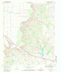
1967 Map of Haystack Mountain
USGS Topo · Published 1971About this map
Haystack Mountain rises as a prominent landmark in this section of Dickens County, overseeing a landscape defined by the intricate drainage systems of the Texas Rolling Plains. The 1967 field survey captures a transition between the elevated plateau and the dissected breaks, where Cottonwood Creek and Duck Creek have carved significant relief into the terrain. This environment is characterized by its hydrological features, including numerous Wells and an intermittent Spring, which were critical for ranching and settlement in this semi-arid region. The presence of a Gravel Pit indicates localized resource extraction, while Hobble Canyon adds to the rugged character of the eastern portion of the sheet. Human passage through the area is marked by the highway and the small Roadside Park, providing a rare point of public infrastructure in an otherwise agricultural and topographical expanse.
Find a feature on this map
9 named features on this map. Tap any name to fly to it.
Don’t see what you’re looking for? This feature index may not catch every label — zoom into the map to look around manually.
Map Details
Editions of this 1967 Haystack Mountain Map
2 editions found
Other maps of this area

1954 · Lubbock
USGS Topo · 1:250,000

1961 · Bunker Hill
USGS Topo · 1:24,000

1965 · Wake
USGS Topo · 1:24,000

1966 · McAdoo
USGS Topo · 1:24,000

1967 · Dickens North
USGS Topo · 1:24,000

1967 · Dickens South
USGS Topo · 1:24,000

1968 · Foreman Chapel
USGS Topo · 1:24,000

1968 · Rustler Camp
USGS Topo · 1:24,000

1968 · Afton
USGS Topo · 1:24,000

1985 · Dickens
USGS Topo · 1:100,000