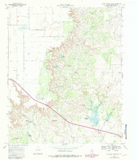
1967 Map of Haystack Mountain
USGS Topo · Published 1981About this map
Haystack Mountain rises above a landscape defined by significant water management and erosion control features in the late 1960s. This survey, later updated with 1979 photogrammetric data, meticulously records numerous earthen structures and spillways, including Spillway Elev 2768 and Spillway Elev 2549, designed to manage runoff in this drainage-heavy portion of Dickens County. The terrain transitions from flat-topped mesas to the carved-out depths of Scobble Canyon and the winding course of Duck Creek. Evidence of local utility and transport is found at the Roadside Park along the highway and a Gravel Pit near the eastern margin. The presence of multiple Wells and a seasonal Spring highlights the critical importance of water access in this semi-arid Texas environment, while smaller topographic features like Hobble and Cottonwood Creek suggest a landscape primarily utilized for ranching and resource extraction during this era.
Find a feature on this map
21 named features on this map. Tap any name to fly to it.
Don’t see what you’re looking for? This feature index may not catch every label — zoom into the map to look around manually.
Map Details
Editions of this 1967 Haystack Mountain Map
2 editions found
Other maps of this area

1954 · Lubbock
USGS Topo · 1:250,000

1961 · Bunker Hill
USGS Topo · 1:24,000

1965 · Wake
USGS Topo · 1:24,000

1966 · McAdoo
USGS Topo · 1:24,000

1967 · Dickens North
USGS Topo · 1:24,000

1967 · Dickens South
USGS Topo · 1:24,000

1967 · Haystack Mountain
USGS Topo · 1:24,000

1968 · Foreman Chapel
USGS Topo · 1:24,000

1968 · Rustler Camp
USGS Topo · 1:24,000

1968 · Afton
USGS Topo · 1:24,000