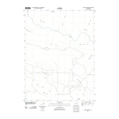
2010 Map of Haystack Rock
USGS Topo · Published 2010About this map
Dinosaur National Monument occupies a significant portion of this terrain, where the high desert plateau meets the winding course of the Yampa River. The landscape is defined by its deep drainages and named formations, including the prominent Haystack Rock and the intricate network of Bear Valley and Bear Valley Ridge. Remote travel across these Moffat County uplands is facilitated by County Rd-14N and Bear Valley Rd, which provide access to geographically distinct areas like Lake Bench and West Cactus Flat.
Find a feature on this map
22 named features on this map. Tap any name to fly to it.
Don’t see what you’re looking for? This feature index may not catch every label — zoom into the map to look around manually.
Map Details
Editions of this 2010 Haystack Rock Map
This is the sole edition of this map. No revisions or reprints were ever made.
Other maps of this area

1907 · Rangely
USGS Topo · 1:125,000

1910 · Rangely
USGS Topo · 1:125,000

1954 · Vernal
USGS Topo · 1:250,000

1958 · Vernal
USGS Topo · 1:250,000

1960 · Vernal
USGS Topo · 1:250,000

1962 · Lazy Y Point
USGS Topo · 1:24,000

1962 · Tanks Peak
USGS Topo · 1:24,000
1962 · M F Mountain
USGS Topo · 1:24,000
1962 · Skull Creek
USGS Topo · 1:24,000

1962 · Indian Water Canyon
USGS Topo · 1:24,000