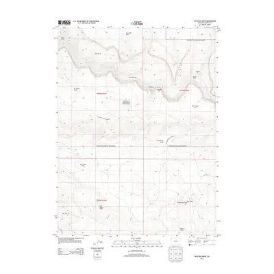
2013 Map of Haystack Rock
USGS Topo · Published 2013About this map
Dinosaur National Monument encompasses a significant portion of this high-desert landscape in Moffat County, where the Yampa River carves a deep, winding path through the northern section. The terrain is defined by a series of dramatic draws and benches, such as Lake Bench and Browns Draw, reflecting a complex geologic history. The southern half of the map shifts toward the elevated Bear Valley Ridge and the drainage of Bear Valley Draw.
Find a feature on this map
23 named features on this map. Tap any name to fly to it.
Don’t see what you’re looking for? This feature index may not catch every label — zoom into the map to look around manually.
Map Details
Editions of this 2013 Haystack Rock Map
This is the sole edition of this map. No revisions or reprints were ever made.
Other maps of this area

1907 · Rangely
USGS Topo · 1:125,000

1910 · Rangely
USGS Topo · 1:125,000

1954 · Vernal
USGS Topo · 1:250,000

1958 · Vernal
USGS Topo · 1:250,000

1960 · Vernal
USGS Topo · 1:250,000

1962 · Lazy Y Point
USGS Topo · 1:24,000

1962 · Tanks Peak
USGS Topo · 1:24,000
1962 · M F Mountain
USGS Topo · 1:24,000
1962 · Skull Creek
USGS Topo · 1:24,000

1962 · Indian Water Canyon
USGS Topo · 1:24,000