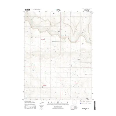
2016 Map of Haystack Rock
USGS Topo · Published 2016About this map
Dinosaur National Monument defines the central character of this Northwest Colorado landscape, where the meandering Yampa River carves through deep canyons and draws. The map illustrates a high-desert terrain marked by dramatic elevation shifts, from the river corridor up to distinctive landmarks like Haystack Rock and the extensive Bear Valley Ridge. Remote access is provided by unpaved routes such as Bear Valley Rd and Co Rd 14N, which connect a series of geographically named features including Iron Mine Basin, Dry Woman Canyon, and Tepee Hole. The distribution of water sources like Bear Valley Spring highlights the vital elements of this arid environment, providing essential context for researchers interested in the historical land use and natural boundaries of Moffat County.
Find a feature on this map
28 named features on this map. Tap any name to fly to it.
Don’t see what you’re looking for? This feature index may not catch every label — zoom into the map to look around manually.
Map Details
Editions of this 2016 Haystack Rock Map
This is the sole edition of this map. No revisions or reprints were ever made.
Other maps of this area

1907 · Rangely
USGS Topo · 1:125,000

1910 · Rangely
USGS Topo · 1:125,000

1954 · Vernal
USGS Topo · 1:250,000

1958 · Vernal
USGS Topo · 1:250,000

1960 · Vernal
USGS Topo · 1:250,000

1962 · Lazy Y Point
USGS Topo · 1:24,000

1962 · Tanks Peak
USGS Topo · 1:24,000
1962 · M F Mountain
USGS Topo · 1:24,000
1962 · Skull Creek
USGS Topo · 1:24,000

1962 · Indian Water Canyon
USGS Topo · 1:24,000