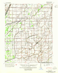
1940 Map of Hayti
USGS Topo · Published 1954About this map
Pemiscot Bayou and Clay Root Bayou dominate this landscape in the Missouri Bootheel, revealing a complex drainage and transport network just before mid-century. The map meticulously documents the transition from river-bound commerce to a rail-and-road economy, evidenced by the St Louis Southwestern and St Louis-San Francisco railroads crossing the terrain. The density of small local institutions is striking, with rural centers like Braggadocio and Steele serving as hubs for numerous country schools and churches such as Friendship Sch and Oak Grove Ch.
Find a feature on this map
87 named features on this map. Tap any name to fly to it.
Don’t see what you’re looking for? This feature index may not catch every label — zoom into the map to look around manually.
Map Details
Editions of this 1940 Hayti Map
2 editions found
Other maps of this area

1934 · Kennett
USGS Topo · 1:62,500

1939 · Portageville
USGS Topo · 1:62,500

1939 · Hales Point
USGS Topo · 1:62,500

1939 · Caruthersville
USGS Topo · 1:62,500

1939 · Blytheville
USGS Topo · 1:62,500

1940 · Pascola
USGS Topo · 1:62,500

1940 · Kennett
USGS Topo · 1:62,500

1940 · Hayti
USGS Topo · 1:62,500

1940 · Piggott
USGS Topo · 1:62,500

1941 · Manila
USGS Topo · 1:62,500