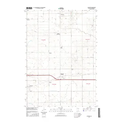
2016 Map of Hayward
USGS Topo · Published 2016About this map
Hayward and the surrounding agricultural landscape of eastern Freeborn County are defined by an extensive network of drainage infrastructure. This modern survey illustrates how Judicial Ditch Number Eighteen, County Ditch Number Twelve, and County Ditch Number Fortyseven serve the low-lying prairie, facilitating the region's productive farmlands. Smaller watercourses like Turtle Cr, Deer Cr, and Woodbury Cr thread through the township grids of t103n r20w and t102n r19w. Small settlements and loading points like Hollandale Junction, Petran, and Muckland underscore the area's agricultural focus. Genealogists will find a high density of burial sites across the landscape, including Oakland Lutheran Cem and Moscow Cem, which reflect the area's early Lutheran and Adventist heritage near communities like South Hollandale and Sigsbee.
Find a feature on this map
47 named features on this map. Tap any name to fly to it.
Don’t see what you’re looking for? This feature index may not catch every label — zoom into the map to look around manually.
Map Details
Editions of this 2016 Hayward Map
This is the sole edition of this map. No revisions or reprints were ever made.
Other maps of this area

1954 · Albert Lea
USGS Topo · 1:62,500

1954 · Hayward
USGS Topo · 1:62,500

1954 · Mason City
USGS Topo · 1:250,000

1957 · Mason City
USGS Topo · 1:250,000

1958 · Mason City
USGS Topo · 1:250,000

1967 · Blooming Prairie
USGS Topo · 1:24,000

1967 · Hollandale
USGS Topo · 1:24,000

1967 · Ellendale
USGS Topo · 1:24,000

1982 · Hayward
USGS Topo · 1:24,000
1982 · London
USGS Topo · 1:24,000