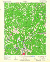
1954 Map of Hazard North
USGS Topo · Published 1966About this map
Hazard and its northern coal-country environs are defined by the winding course of the North Fork Kentucky River and the industrial infrastructure of the Louisville and Nashville railroad. The landscape in the mid-1950s is a complex network of hollows and ridges, where settlements like Blue Diamond and Hardburly sit tucked into the valleys. The map documents a transition in local transportation and commerce, seen in the presence of the Hazard Airport near Airport Gardens and the numerous small schools and churches that served these mountain communities, such as Jones Sch and the Lost Creek Community Chapel. The concentration of small industrial markers like Gas Well sites alongside established neighborhood names like Walkertown and Allais illustrates the deeply integrated nature of the region's resource extraction and residential life.
Find a feature on this map
76 named features on this map. Tap any name to fly to it.
Don’t see what you’re looking for? This feature index may not catch every label — zoom into the map to look around manually.
Map Details
Editions of this 1954 Hazard North Map
2 editions found
Other maps of this area

1891 · Hazard
USGS Topo · 1:125,000

1913 · Buckhorn
USGS Topo · 1:62,500

1914 · Troublesome
USGS Topo · 1:62,500

1916 · Cornettsville
USGS Topo · 1:62,500

1916 · Hyden
USGS Topo · 1:48,000

1919 · Hyden
USGS Topo · 1:62,500

1954 · Noble
USGS Topo · 1:24,000

1954 · Krypton
USGS Topo · 1:24,000
1954 · Hyden East
USGS Topo · 1:24,000
1954 · Haddix
USGS Topo · 1:24,000