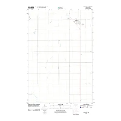
2011 Map of Hazelton
USGS Topo · Published 2011About this map
Hazelton serves as the central hub of this North Dakota landscape, situated at the intersection of a grid-iron road network and regional transit lines. The town's layout is defined by residential and commercial streets such as Main St and Cottage St, supporting a community anchored by local infrastructure like the Hazelton Municipal Airport and the Saint Paul Cemetery. The surrounding terrain of Emmons County is characterized by a disciplined section-line road system, including 65th St SE and 4th Ave SE, which organize the agricultural land. Natural drainage is provided by the winding paths of Hawk Creek and Sand Creek, which cut across the geometric precision of the township and range divisions. This survey captures the rural character of the northern Great Plains, where small-town development remains closely tied to the surrounding prairie and its watercourses.
Find a feature on this map
23 named features on this map. Tap any name to fly to it.
Don’t see what you’re looking for? This feature index may not catch every label — zoom into the map to look around manually.
Map Details
Editions of this 2011 Hazelton Map
This is the sole edition of this map. No revisions or reprints were ever made.
Other maps of this area

1954 · Bismarck
USGS Topo · 1:250,000

1958 · Bismarck
USGS Topo · 1:250,000

1971 · Moffit SW
USGS Topo · 1:24,000

1971 · Hazelton
USGS Topo · 1:24,000

1971 · Moffit SE
USGS Topo · 1:24,000

1971 · Hazelton SW
USGS Topo · 1:24,000
1971 · Hazelton NW
USGS Topo · 1:24,000

1971 · Temvik
USGS Topo · 1:24,000

1975 · Dana
USGS Topo · 1:24,000

1975 · Appert Lake
USGS Topo · 1:24,000