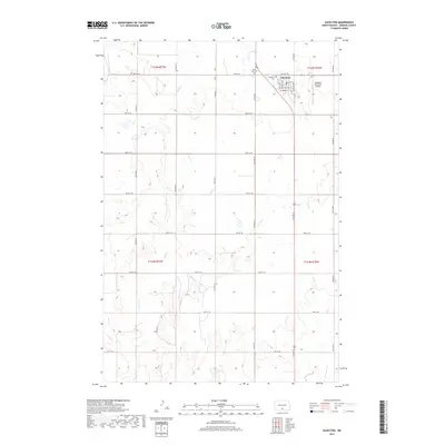
2017 Map of Hazelton
USGS Topo · Published 2017About this map
Hazelton serves as the primary hub of this rural Emmons County landscape, positioned within a grid of section lines that define the agricultural character of central North Dakota. The town's layout is clearly visible, anchored by Main St and Hazel Ave, while its local infrastructure is documented through the Hazelton Municipal Airport to the east. The surrounding prairie is drained by the meandering courses of Sand Cr and Hauk Cr, providing a contrast to the geometric precision of the township boundaries like t135n r77w. Local heritage is preserved at the Hazelton Cem and Saint Paul Cem, which stand as significant landmarks for those tracing family history in this farming community. The map reflects a modern era where traditional section roads like 64th St SE remain the vital arteries connecting isolated homesteads to the municipal center.
Find a feature on this map
29 named features on this map. Tap any name to fly to it.
Don’t see what you’re looking for? This feature index may not catch every label — zoom into the map to look around manually.
Map Details
Editions of this 2017 Hazelton Map
This is the sole edition of this map. No revisions or reprints were ever made.
Other maps of this area

1954 · Bismarck
USGS Topo · 1:250,000

1958 · Bismarck
USGS Topo · 1:250,000

1971 · Moffit SW
USGS Topo · 1:24,000

1971 · Hazelton
USGS Topo · 1:24,000

1971 · Moffit SE
USGS Topo · 1:24,000

1971 · Hazelton SW
USGS Topo · 1:24,000
1971 · Hazelton NW
USGS Topo · 1:24,000

1971 · Temvik
USGS Topo · 1:24,000

1975 · Dana
USGS Topo · 1:24,000

1975 · Appert Lake
USGS Topo · 1:24,000