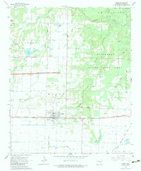
1964 Map of Hazen
USGS Topo · Published 1983About this map
Hazen serves as the central hub of this Prairie County landscape, situated at the intersection of the Chicago Rock Island and Pacific railroad and a highway network undergoing significant change. At the time of this 1960s survey, Interstate construction was underway, marked by a prominent Under Construction corridor north of the town center. The surrounding rural character is defined by the Wattensaw state game area and a complex drainage system including Wattensaw Bayou and Hurricane Creek. Genealogists will find several local burial sites, such as Hazen Cem, Green Grove Cem, and Old Bethel Cem, while the town's aviation history is noted by Fowlkes Field. Evidence of early transit persists in the form of an Old Railroad Grade running south toward Oak Creek, reflecting the evolving transportation patterns of the Grand Prairie region.
Find a feature on this map
40 named features on this map. Tap any name to fly to it.
Don’t see what you’re looking for? This feature index may not catch every label — zoom into the map to look around manually.
Map Details
Editions of this 1964 Hazen Map
3 editions found
Other maps of this area

1935 · Hazen
USGS Topo · 1:62,500

1935 · Clarendon
USGS Topo · 1:62,500

1937 · Stuttgart
USGS Topo · 1:62,500

1939 · Stuttgart
USGS Topo · 1:62,500

1941 · Hazen
USGS Topo · 1:62,500

1941 · De Valls Bluff
USGS Topo · 1:62,500

1941 · Clarendon
USGS Topo · 1:62,500

1948 · Helena
USGS Topo · 1:250,000

1950 · Helena
USGS Topo · 1:250,000

1955 · Helena
USGS Topo · 1:250,000