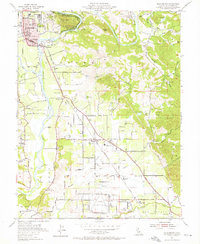
1955 Map of Healdsburg
USGS Topo · Published 1956About this map
The Russian River winds through the heart of this mid-century landscape, anchoring a valley defined by agricultural tradition and emerging infrastructure. Near the bend of the river, Healdsburg serves as the primary hub, with its grid established around local landmarks like the Oak Mound Cemetery and Fitch Mtn. The surrounding countryside is dotted with small settlements and ranching outposts such as Bailhache, Grant, and El Rancho Del Obispo. Transport is dictated by the Northwestern Pacific railroad and the Redwood Highway, which parallel the river's path south toward the expansive Sonoma County Airport.
Find a feature on this map
55 named features on this map. Tap any name to fly to it.
Don’t see what you’re looking for? This feature index may not catch every label — zoom into the map to look around manually.
Map Details
Editions of this 1955 Healdsburg Map
3 editions found
Other maps of this area

1916 · Santa Rosa
USGS Topo · 1:62,500

1920 · Healdsburg
USGS Topo · 1:62,500

1927 · Calistoga
USGS Topo · 1:62,500

1933 · Healdsburg
USGS Topo · 1:48,000

1935 · Sebastopol
USGS Topo · 1:48,000

1940 · Healdsburg
USGS Topo · 1:62,500

1942 · Sebastopol
USGS Topo · 1:62,500

1943 · Calistoga
USGS Topo · 1:62,500

1944 · Santa Rosa
USGS Topo · 1:62,500

1945 · Calistoga
USGS Topo · 1:62,500