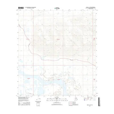
2016 Map of Healy A-1 SW
USGS Topo · Published 2016About this map
The Susitna River dominates the southern landscape of this Matanuska-Susitna borough quadrangle, winding through a network of wetlands and seasonal water bodies. Further north, the Denali Highway provides the primary transit corridor, cutting east-to-west across the midsection of the map. This infrastructure links the high-altitude terrain with localized landmarks such as Swampbuggy Lake and Hatched Lake. The drainage patterns here are complex, defined by numerous seasonal streams including Windy Cr, Lake Cr, Nowater Cr, and Raft Cr. The map's detail provides a clear view of the relationship between the major river system and the high mountain passes, illustrating how the highway navigates the challenging topography of the region. This 2016 survey effectively illustrates the modern character of this stretch of the Alaska interior, where the river valley and the lone highway define human and natural movement.
Find a feature on this map
14 named features on this map. Tap any name to fly to it.
Don’t see what you’re looking for? This feature index may not catch every label — zoom into the map to look around manually.
Map Details
Editions of this 2016 Healy A-1 SW Map
This is the sole edition of this map. No revisions or reprints were ever made.
Other maps of this area

1949 · Healy A-1
USGS Topo · 1:63,360

1950 · Talkeetna Mountains
USGS Topo · 1:250,000

1951 · Healy
USGS Topo · 1:250,000

1951 · Talkeetna Mountains D-2
USGS Topo · 1:63,360

1951 · Talkeetna Mountains D-1
USGS Topo · 1:63,360

1951 · Healy A-2
USGS Topo · 1:63,360
1952 · Talkeetna Mountains D-1
USGS Topo · 1:63,360
1952 · Healy A-1
USGS Topo · 1:63,360

1952 · Healy A-2
USGS Topo · 1:63,360
1952 · Talkeetna Mountains D-2
USGS Topo · 1:63,360