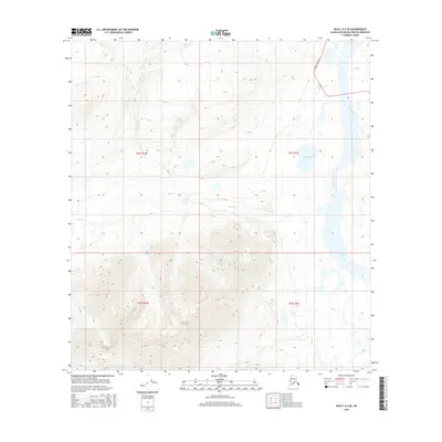
2016 Map of Healy A-2 SE
USGS Topo · Published 2016About this map
The Susitna River dominates the eastern edge of this interior landscape, carving a broad valley through the mountainous terrain of the Matanuska-Susitna region. In the northeast, the Denali Highway cuts across the upland slopes, providing a critical transportation link through this high-latitude wilderness. The drainage patterns are defined by several key tributaries, including Butte Cr and Wickersham Cr, which flow through deep-cut valleys toward the river basin. High-elevation features like Snodgrass Lake and the nearby Windy Cr illustrate the glacial and alpine water systems typical of this part of the Alaska Range. This 2016 survey documents the geography of the area just before significant environmental shifts, showing the precise relationship between the highway route and the surrounding waterways.
Find a feature on this map
10 named features on this map. Tap any name to fly to it.
Don’t see what you’re looking for? This feature index may not catch every label — zoom into the map to look around manually.
Map Details
Editions of this 2016 Healy A-2 SE Map
This is the sole edition of this map. No revisions or reprints were ever made.
Other maps of this area

1949 · Healy A-1
USGS Topo · 1:63,360

1950 · Talkeetna Mountains
USGS Topo · 1:250,000

1951 · Healy
USGS Topo · 1:250,000

1951 · Talkeetna Mountains D-2
USGS Topo · 1:63,360

1951 · Talkeetna Mountains D-1
USGS Topo · 1:63,360

1951 · Healy A-2
USGS Topo · 1:63,360
1952 · Talkeetna Mountains D-1
USGS Topo · 1:63,360
1952 · Healy A-1
USGS Topo · 1:63,360

1952 · Healy A-2
USGS Topo · 1:63,360
1952 · Talkeetna Mountains D-2
USGS Topo · 1:63,360