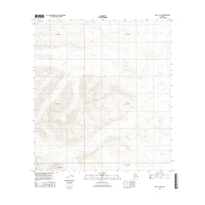
2016 Map of Healy A-3 NW
USGS Topo · Published 2016About this map
Brushkana Cr winds through this interior landscape within the Matanuska-Susitna region, defining the primary drainage pattern across the northern sections of the sheet. The terrain is characterized by the complex topography between the Talkeetna Mountains and the Alaska Range, where Meadow Cr joins the network of seasonal and perennial waterways. This 2016 survey captures the area's wilderness character, marked only by the established township and range boundaries of the Public Land Survey System, such as t20s r5w and t20s r4w. The absence of developed roads or named settlements underscores the pristine nature of this subarctic environment, making it a critical reference for understanding the natural hydrology and elevation profiles of the region before any potential modern infrastructure shifts.
Find a feature on this map
8 named features on this map. Tap any name to fly to it.
Don’t see what you’re looking for? This feature index may not catch every label — zoom into the map to look around manually.
Map Details
Editions of this 2016 Healy A-3 NW Map
This is the sole edition of this map. No revisions or reprints were ever made.
Other maps of this area

1949 · Healy B-4
USGS Topo · 1:63,360

1950 · Healy A-3
USGS Topo · 1:63,360

1950 · Healy B-3
USGS Topo · 1:63,360

1950 · Healy A-4
USGS Topo · 1:63,360

1951 · Healy
USGS Topo · 1:250,000

1951 · Healy B-4
USGS Topo · 1:63,360

1952 · Healy A-4
USGS Topo · 1:63,360
1952 · Healy A-3
USGS Topo · 1:63,360
1952 · Healy B-3
USGS Topo · 1:63,360

1956 · Healy
USGS Topo · 1:250,000