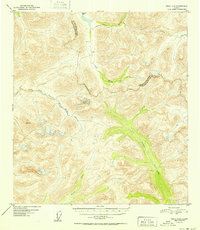
1952 Map of Healy A-4
USGS Topo · Published 1952About this map
Glacial drainages and high-altitude mountain passes define this interior Alaskan landscape as it was documented in the mid-twentieth century. The watershed is divided by the Tsusena River flowing south and the Jack River and Soule Creek flowing north, reflecting the complex hydrology of the Alaska Range. A significant administrative line cuts across the terrain, marking the Fourth Judicial Division Third Judicial Division boundary, which separated legal jurisdictions in the territory before statehood. The topography is anchored by Caribou Pass in the north and the East Fork Chulitna River to the west. This 1952 edition was derived from aerial photography taken in 1949, capturing the wilderness before modern road access or significant development altered the natural course of waterways like Portage Creek.
Find a feature on this map
9 named features on this map. Tap any name to fly to it.
Don’t see what you’re looking for? This feature index may not catch every label — zoom into the map to look around manually.
Map Details
Editions of this 1952 Healy A-4 Map
2 editions found

Other maps of this area

1949 · Healy B-4
USGS Topo · 1:63,360

1950 · Talkeetna Mountains
USGS Topo · 1:250,000

1950 · Talkeetna Mountains D-5
USGS Topo · 1:63,360

1950 · Healy A-3
USGS Topo · 1:63,360

1950 · Healy B-3
USGS Topo · 1:63,360

1950 · Healy A-4
USGS Topo · 1:63,360

1950 · Healy A-5
USGS Topo · 1:63,360

1950 · Healy B-5
USGS Topo · 1:63,360

1951 · Healy
USGS Topo · 1:250,000

1951 · Talkeetna Mountains D-5
USGS Topo · 1:63,360