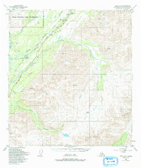
1950 Map of Healy A-5
USGS Topo · Published 1993About this map
The Alaska Railroad and the George Parks Highway carve a primary transportation corridor through this high-altitude landscape, following the drainage of the Chulitna River. The survey reveals the critical importance of mountain passes for interior movement, specifically Broad Pass and Honolulu Pass, which facilitate the route between the Susitna and Tanana watersheds. Within the northwestern corner, the boundary of Denali National Park and Preserve encompasses the upper reaches of the Bull River.
Find a feature on this map
23 named features on this map. Tap any name to fly to it.
Don’t see what you’re looking for? This feature index may not catch every label — zoom into the map to look around manually.
Map Details
Editions of this 1950 Healy A-5 Map
4 editions found
Other maps of this area

1949 · Talkeetna Mountains D-6
USGS Topo · 1:63,360

1949 · Healy B-4
USGS Topo · 1:63,360

1949 · Healy A-6
USGS Topo · 1:63,360

1950 · Talkeetna Mountains
USGS Topo · 1:250,000

1950 · Talkeetna Mountains D-5
USGS Topo · 1:63,360

1950 · Healy A-4
USGS Topo · 1:63,360

1950 · Healy A-5
USGS Topo · 1:63,360

1950 · Healy B-5
USGS Topo · 1:63,360

1951 · Healy
USGS Topo · 1:250,000

1951 · Talkeetna Mountains D-5
USGS Topo · 1:63,360