
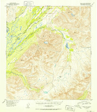
1952 Map of Healy A-5
USGS Topo · Published 1952About this map
The mountain passes and river forks of the Alaska interior are documented here during the early 1950s, centered on the strategic corridor where The Alaska Railroad follows the Middle Fork Chulitna River. The settlement of Colorado serves as a primary reference point along the rail line, accompanied by a nearby Airstrip that highlights the era's reliance on bush aviation for remote access. This survey details the complex drainage systems of the East Fork Chulitna River and Honolulu Creek as they navigate high-altitude terrain defined by Broad Pass and Honolulu Pass. The presence of established survey markers like VABM Chulitna and VABM Bull indicates the intense mapping effort required to navigate this portion of the Third Judicial Division before modern infrastructure was fully developed.
Find a feature on this map
25 named features on this map. Tap any name to fly to it.
Don’t see what you’re looking for? This feature index may not catch every label — zoom into the map to look around manually.
Map Details
Editions of this 1952 Healy A-5 Map
2 editions found
Other maps of this area

1949 · Talkeetna Mountains D-6
USGS Topo · 1:63,360

1949 · Healy B-4
USGS Topo · 1:63,360

1949 · Healy A-6
USGS Topo · 1:63,360

1950 · Talkeetna Mountains
USGS Topo · 1:250,000

1950 · Talkeetna Mountains D-5
USGS Topo · 1:63,360

1950 · Healy A-4
USGS Topo · 1:63,360

1950 · Healy A-5
USGS Topo · 1:63,360

1950 · Healy B-5
USGS Topo · 1:63,360

1951 · Healy
USGS Topo · 1:250,000

1951 · Talkeetna Mountains D-5
USGS Topo · 1:63,360