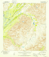
1952 Map of Healy A-5
USGS Topo · Published 1952About this map
Middle Fork Chulitna River and the East Fork Chulitna River converge in this mid-century survey of the Alaska interior, marking a critical corridor for transportation and water drainage. The The Alaska Railroad follows the path of the Middle Fork, passing through the settlement of Colorado where a small Airstrip and several buildings are noted. This rail line was the primary artery for the region during the early 1950s, navigating the dramatic elevation changes around Broad Pass and the high peaks of the Alaska Range. High-altitude survey markers like VABM Chulitna 6495 and VABM Pass 5603 overlook a landscape of braided riverbeds and drainage systems including Fourth of July Creek and Honolulu Creek. The map also captures the Hardage trail, suggesting the enduring importance of ground routes even as aviation infrastructure began to appear.
Find a feature on this map
27 named features on this map. Tap any name to fly to it.
Don’t see what you’re looking for? This feature index may not catch every label — zoom into the map to look around manually.
Map Details
Editions of this 1952 Healy A-5 Map
2 editions found

Other maps of this area

1949 · Talkeetna Mountains D-6
USGS Topo · 1:63,360

1949 · Healy B-4
USGS Topo · 1:63,360

1949 · Healy A-6
USGS Topo · 1:63,360

1950 · Talkeetna Mountains
USGS Topo · 1:250,000

1950 · Talkeetna Mountains D-5
USGS Topo · 1:63,360

1950 · Healy A-4
USGS Topo · 1:63,360

1950 · Healy A-5
USGS Topo · 1:63,360

1950 · Healy B-5
USGS Topo · 1:63,360

1951 · Healy
USGS Topo · 1:250,000

1951 · Talkeetna Mountains D-5
USGS Topo · 1:63,360