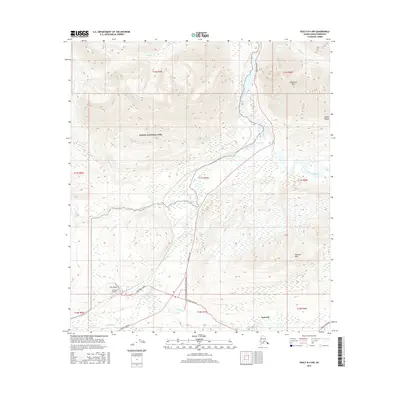
2016 Map of Healy B-4 NW
USGS Topo · Published 2016About this map
Cantwell sits at a critical junction in the Alaskan interior, marking the intersection of the north-south Parks Highway and the westward Denali Highway. This survey illustrates the settlement's infrastructure, including the Cantwell Airport and a local street network featuring Dall Avenue, Toklat Road, and Cantwell Road. The surrounding landscape is defined by the heavy drainage of the Nenana River and Jack River, which flow through a broad valley flanked by significant elevations. To the north, Panorama Mtn rises above the riverbanks, while the southern reaches are dominated by the Reindeer Hills. The map also captures the southeastern boundary of Denali National Park, where the terrain transitions from the developed corridor of the highway to the protected wilderness of the Alaska Range.
Find a feature on this map
29 named features on this map. Tap any name to fly to it.
Don’t see what you’re looking for? This feature index may not catch every label — zoom into the map to look around manually.
Map Details
Editions of this 2016 Healy B-4 NW Map
This is the sole edition of this map. No revisions or reprints were ever made.
Other maps of this area

1949 · Healy B-4
USGS Topo · 1:63,360

1950 · Healy C-4
USGS Topo · 1:63,360

1950 · Healy B-5
USGS Topo · 1:63,360

1951 · Healy
USGS Topo · 1:250,000

1951 · Healy B-5
USGS Topo · 1:63,360

1951 · Healy B-4
USGS Topo · 1:63,360

1952 · Healy C-5
USGS Topo · 1:63,360
1952 · Healy C-4
USGS Topo · 1:63,360

1953 · Healy C-5
USGS Topo · 1:63,360

1953 · Healy B-5
USGS Topo · 1:63,360