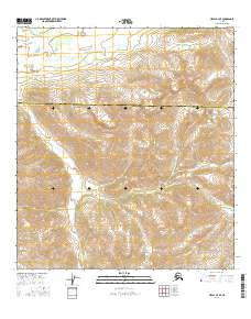
2016 Map of Healy B-4 SE
USGS Topo · Published 2016About this map
High-altitude interior terrain defines this 2016 survey along the boundary between the Denali Borough and Matanuska-Susitna Borough. The landscape is dominated by the complex drainage systems of the Jack River, which flows through the western portion of the map. Its tributary, the East Fork Jack River, cuts a prominent path across the central and eastern sections, illustrating the glacial and alpine hydrology of the region. On the northeastern edge, Edmonds Creek provides further evidence of the area's intricate network of mountain streams. This map captures the remote character of the Alaska Range foothills, showing a vast area devoid of modern road infrastructure, where the natural watercourses and borough lines serve as the primary landmarks for navigation and land management.
Find a feature on this map
8 named features on this map. Tap any name to fly to it.
Don’t see what you’re looking for? This feature index may not catch every label — zoom into the map to look around manually.
Map Details
Editions of this 2016 Healy B-4 SE Map
This is the sole edition of this map. No revisions or reprints were ever made.
Other maps of this area

1949 · Healy B-4
USGS Topo · 1:63,360

1950 · Healy A-3
USGS Topo · 1:63,360

1950 · Healy B-3
USGS Topo · 1:63,360

1950 · Healy A-4
USGS Topo · 1:63,360

1951 · Healy
USGS Topo · 1:250,000

1951 · Healy B-4
USGS Topo · 1:63,360

1952 · Healy A-4
USGS Topo · 1:63,360
1952 · Healy A-3
USGS Topo · 1:63,360
1952 · Healy B-3
USGS Topo · 1:63,360

1956 · Healy
USGS Topo · 1:250,000