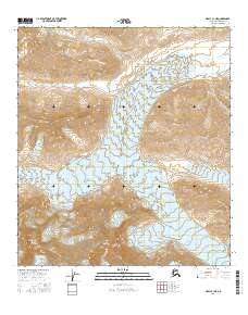
2016 Map of Healy C-1 NE
USGS Topo · Published 2016About this map
Mt Deborah and Hess Mtn anchor the southern reaches of this landscape in the Denali region, where high-altitude ice and glacial meltwaters define the terrain. The vast Gillam Glacier dominates the central portion of the map, flowing between ridges into the northern valley. To the south and west, the heads of the Yanert Glacier and W Fork Glacier reveal a complex glacial system where permanent ice fields meet the source waters of regional drainage. In the northeast, the East Fork Little Delta River emerges from the high country, illustrating the hydrography of the interior's alpine environment. This 2016 survey by the U.S. Geological Survey provides a detailed topographic record of these remote peaks and ice flows, marking the intricate contour lines of some of Alaska's most prominent mountain features.
Find a feature on this map
12 named features on this map. Tap any name to fly to it.
Don’t see what you’re looking for? This feature index may not catch every label — zoom into the map to look around manually.
Map Details
Editions of this 2016 Healy C-1 NE Map
This is the sole edition of this map. No revisions or reprints were ever made.
Other maps of this area

1949 · Healy D-1
USGS Topo · 1:63,360

1950 · Mount Hayes
USGS Topo · 1:250,000

1950 · Mount Hayes D-6
USGS Topo · 1:63,360

1951 · Healy
USGS Topo · 1:250,000

1951 · Mount Hayes
USGS Topo · 1:250,000

1951 · Healy C-1
USGS Topo · 1:63,360

1951 · Mount Hayes C-6
USGS Topo · 1:63,360
1952 · Healy D-1
USGS Topo · 1:63,360
1952 · Mount Hayes D-6
USGS Topo · 1:63,360

1955 · Mount Hayes
USGS Topo · 1:250,000