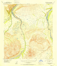
1952 Map of Mount Hayes D-6
USGS Topo · Published 1952About this map
Glacial drainages and high mountain peaks dominate this interior Alaskan landscape as it appeared in the mid-twentieth century. The braided channel of the Little Delta River and its major tributaries, the West Fork and East Fork, create a complex network of gravel bars and shifting watercourses in the western half of the map. To the east, Delta Creek follows a similar alluvial path, fed by smaller streams like Ptarmigan Creek. Elevation is anchored by several prominent triangulation stations, including VABM 5932 Dyer and VABM 5322 Aux, which mark the high ridges above the valleys of Iowa Creek and Buchanan Creek. This map captures a pristine wilderness era before significant modern infrastructure reached these specific reaches of the Alaska-Fourth Judicial Division, preserving the original hydrography of these subarctic river systems.
Find a feature on this map
10 named features on this map. Tap any name to fly to it.
Don’t see what you’re looking for? This feature index may not catch every label — zoom into the map to look around manually.
Map Details
Editions of this 1952 Mount Hayes D-6 Map
2 editions found
Other maps of this area

1949 · Big Delta A-6
USGS Topo · 1:63,360

1949 · Fairbanks A-1
USGS Topo · 1:63,360

1949 · Healy D-1
USGS Topo · 1:63,360

1950 · Fairbanks
USGS Topo · 1:250,000

1950 · Mount Hayes
USGS Topo · 1:250,000

1950 · Big Delta
USGS Topo · 1:250,000

1950 · Big Delta A-5
USGS Topo · 1:63,360

1950 · Mount Hayes D-6
USGS Topo · 1:63,360

1950 · Mount Hayes D-5
USGS Topo · 1:63,360

1951 · Healy
USGS Topo · 1:250,000