
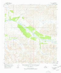
1949 Map of Healy C-3
USGS Topo · Published 1965About this map
Yanert Fork dominates the drainage patterns across this interior Alaskan landscape, which was recorded during a 1949 aerial survey. This area is characterized by high-elevation drainage systems where Grizzly Creek and Dean Creek flow through terrain that remained largely unsurveyed on the ground at the time of publication. The Bureau of Land Management predetermined land lines for this portion of the Fairbanks Meridian, though no roads or trails were documented in this wilderness. Tributaries such as Dick Creek and Moose Creek create a complex hydrological network typical of the Alaska Range's northern slopes. The map also records smaller named features like Edgar Cr and Louis Creek, providing essential reference points for early mid-century surveyors and wilderness navigators.
Find a feature on this map
8 named features on this map. Tap any name to fly to it.
Don’t see what you’re looking for? This feature index may not catch every label — zoom into the map to look around manually.
Map Details
Editions of this 1949 Healy C-3 Map
2 editions found
Other maps of this area

1949 · Healy B-4
USGS Topo · 1:63,360

1949 · Healy B-2
USGS Topo · 1:63,360

1950 · Healy D-4
USGS Topo · 1:63,360

1950 · Healy C-4
USGS Topo · 1:63,360

1950 · Healy B-3
USGS Topo · 1:63,360

1950 · Healy D-3
USGS Topo · 1:63,360

1951 · Healy
USGS Topo · 1:250,000

1951 · Healy B-4
USGS Topo · 1:63,360

1951 · Healy C-2
USGS Topo · 1:63,360
1951 · Healy D-2
USGS Topo · 1:63,360