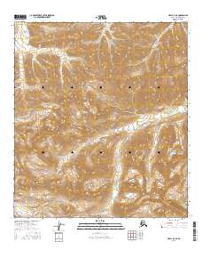
2016 Map of Healy C-5 SE
USGS Topo · Published 2016About this map
Denali National Park encompasses the high-altitude terrain shown in this 2016 survey, where the peaks of the Alaska Range dominate the southern landscape. The topography is defined by significant landmarks such as Fang Mtn, which towers over the headwaters of several critical glacial drainage systems. The map traces the intricate paths of the Savage River and the Sanctuary River as they flow north through deep valleys, alongside the winding course of Riley Creek (also labeled Riley Cr). This USGS study serves as a detailed record of the glacial morphology and hydrography within the interior of the park, capturing the undisturbed natural drainage patterns and the complex contours of the mountain ridges as they were documented in the mid-2010s.
Find a feature on this map
13 named features on this map. Tap any name to fly to it.
Don’t see what you’re looking for? This feature index may not catch every label — zoom into the map to look around manually.
Map Details
Editions of this 2016 Healy C-5 SE Map
This is the sole edition of this map. No revisions or reprints were ever made.
Other maps of this area

1949 · Healy B-4
USGS Topo · 1:63,360

1950 · Healy C-4
USGS Topo · 1:63,360

1950 · Healy B-5
USGS Topo · 1:63,360

1951 · Healy
USGS Topo · 1:250,000

1951 · Healy B-5
USGS Topo · 1:63,360

1951 · Healy B-4
USGS Topo · 1:63,360

1952 · Healy C-5
USGS Topo · 1:63,360
1952 · Healy C-4
USGS Topo · 1:63,360

1953 · Healy C-5
USGS Topo · 1:63,360

1953 · Healy B-5
USGS Topo · 1:63,360