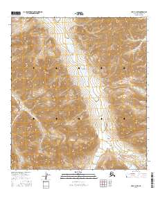
2016 Map of Healy C-5 SW
USGS Topo · Published 2016About this map
Denali National Park encompasses this high-elevation landscape within the Alaska Range, characterized by significant relief and glacial drainage patterns. The interior of the park is defined by the north-south corridor of the Sanctuary River, which flows through the eastern half of the map area. To the west, the distinctive peaks of Double Mtn rise above the drainage of Calico Creek. This portion of the park is largely wilderness, centered on the protected Refuge Valley. The map detail provides a clear view of the complex topography and hydrological network that exists within the northern reaches of the range, showing the remote character of this protected subarctic environment as it was documented in 2016.
Find a feature on this map
11 named features on this map. Tap any name to fly to it.
Don’t see what you’re looking for? This feature index may not catch every label — zoom into the map to look around manually.
Map Details
Editions of this 2016 Healy C-5 SW Map
This is the sole edition of this map. No revisions or reprints were ever made.
Other maps of this area

1950 · Healy B-5
USGS Topo · 1:63,360

1951 · Healy
USGS Topo · 1:250,000

1951 · Healy B-5
USGS Topo · 1:63,360

1952 · Healy C-5
USGS Topo · 1:63,360

1953 · Healy C-5
USGS Topo · 1:63,360

1953 · Healy B-5
USGS Topo · 1:63,360

1954 · Healy C-6
USGS Topo · 1:63,360

1954 · Healy B-6
USGS Topo · 1:63,360
1956 · Healy B-5
USGS Topo · 1:63,360

1956 · Healy
USGS Topo · 1:250,000