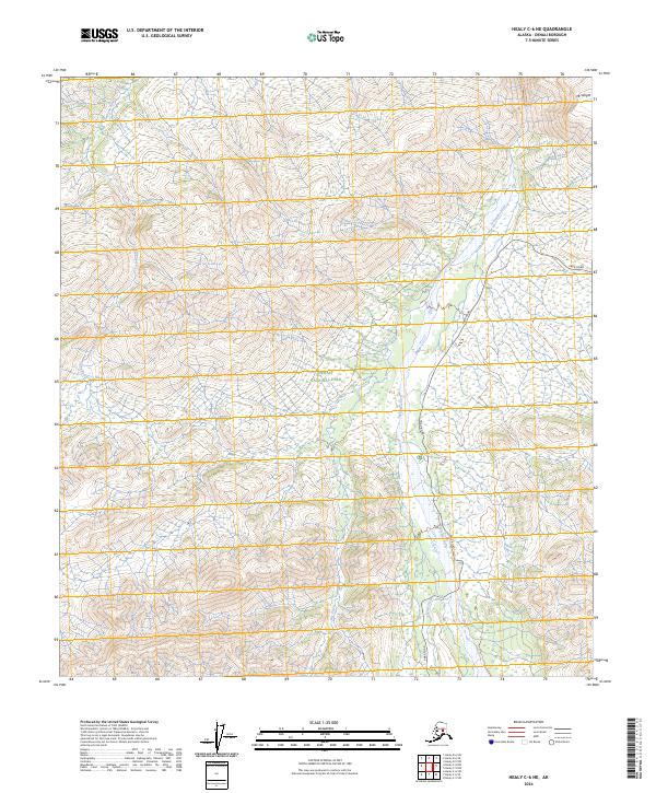
2024 Map of Healy C-6 NE
USGS Topo · Published 2024About this map
Denali National Park and the surrounding Denali Wilderness define this interior Alaskan landscape, where glacial-fed rivers carve through steep mountain terrain. The eastern corridor is navigated by Park Road, which follows the contours of the valley near Igloo Creek before crossing the braided channels of the Teklanika River. To the north, Mt Wright rises prominently above the drainage systems of the Sushana River and Big Creek. This survey details the complex topography and hydrological patterns of the region, illustrating the vast roadless reaches that extend west from the primary access route. The map serves as a precise record of the corridor's infrastructure and the expansive protected wilderness that remains largely untouched by development.
Find a feature on this map
14 named features on this map. Tap any name to fly to it.
Don’t see what you’re looking for? This feature index may not catch every label — zoom into the map to look around manually.
Map Details
Editions of this 2024 Healy C-6 NE Map
This is the sole edition of this map. No revisions or reprints were ever made.
Other maps of this area

1951 · Healy
USGS Topo · 1:250,000

1951 · Healy D-6
USGS Topo · 1:63,360

1951 · Healy D-5
USGS Topo · 1:63,360

1952 · Healy D-5
USGS Topo · 1:63,360

1952 · Healy C-5
USGS Topo · 1:63,360

1953 · Healy C-5
USGS Topo · 1:63,360

1954 · Healy C-6
USGS Topo · 1:63,360
1954 · Healy D-6
USGS Topo · 1:63,360

1956 · Healy
USGS Topo · 1:250,000
2014 · Healy C-6 SW
USGS Topo · 1:25,000