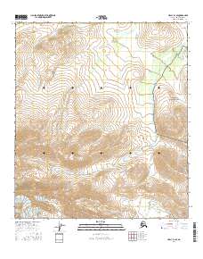
2016 Map of Healy D-1 SE
USGS Topo · Published 2016About this map
The Alaska Range defines the steep and high-elevation terrain of this Alaska interior quadrangle, where sharp contour lines trace the drainage basins of the high country. Central to the landscape is the winding course of Buchanan Creek, which flows through the southern half of the map, carving a significant valley across several townships. To the northwest, the headwaters of O'Brien Cr emerge from the high ridges. This is a wilderness environment where the primary markers of human organization are the public land survey system lines, including the corners of t12s r3e and t13s r4e. The map illustrates the hydrological patterns of these high-latitude watersheds before they join larger systems further down the range.
Find a feature on this map
8 named features on this map. Tap any name to fly to it.
Don’t see what you’re looking for? This feature index may not catch every label — zoom into the map to look around manually.
Map Details
Editions of this 2016 Healy D-1 SE Map
This is the sole edition of this map. No revisions or reprints were ever made.
Other maps of this area

1949 · Healy D-1
USGS Topo · 1:63,360

1950 · Mount Hayes
USGS Topo · 1:250,000

1950 · Mount Hayes D-6
USGS Topo · 1:63,360

1951 · Healy
USGS Topo · 1:250,000

1951 · Mount Hayes
USGS Topo · 1:250,000

1951 · Healy C-1
USGS Topo · 1:63,360

1951 · Mount Hayes C-6
USGS Topo · 1:63,360
1952 · Healy D-1
USGS Topo · 1:63,360
1952 · Mount Hayes D-6
USGS Topo · 1:63,360

1955 · Mount Hayes
USGS Topo · 1:250,000