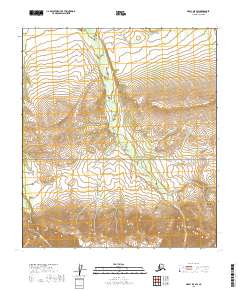
2019 Map of Healy D-5 SW
USGS Topo · Published 2019About this map
Denali National Park encompasses this entire interior landscape, where the southern portion is dominated by the prominent elevation of Mt Margaret. This survey reveals a complex hydrological network defining the northern subarctic terrain, characterized by the parallel courses of the Savage River and the Sanctuary River as they flow northward through the park's protected wilderness. These major drainage systems are fed by numerous tributaries, including Sunday Cr, Pinto Cr, and Eva Cr, which carve through the high mountain valleys. The map provides a detailed view of the natural topography and watershed boundaries in this region of the Alaska Range before the terrain descends into the lower tundra basins further north.
Find a feature on this map
11 named features on this map. Tap any name to fly to it.
Don’t see what you’re looking for? This feature index may not catch every label — zoom into the map to look around manually.
Map Details
Editions of this 2019 Healy D-5 SW Map
This is the sole edition of this map. No revisions or reprints were ever made.
Other maps of this area

1951 · Healy
USGS Topo · 1:250,000

1951 · Healy D-6
USGS Topo · 1:63,360

1951 · Healy D-5
USGS Topo · 1:63,360

1952 · Healy D-5
USGS Topo · 1:63,360

1952 · Healy C-5
USGS Topo · 1:63,360

1953 · Healy C-5
USGS Topo · 1:63,360

1954 · Healy C-6
USGS Topo · 1:63,360
1954 · Healy D-6
USGS Topo · 1:63,360

1956 · Healy
USGS Topo · 1:250,000
2016 · Healy D-5 NE
USGS Topo · 1:25,000