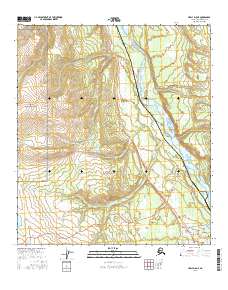
2016 Map of Healy D-5 NE
USGS Topo · Published 2016About this map
The Nenana River carves a dominant path through this landscape, flanked by the high-alpine terrain of Denali National Park. This 2016 survey highlights a corridor of critical transportation and infrastructure, anchored by the Parks Highway and the remote outpost of Ferry. To the south, the settlement of Healy serves as a modern focal point, where Lignite Road and Stampede Road provide access to the interior. The drainage network is intricately mapped, featuring numerous tributaries such as Slate Cr, Panguingue Cr, and Little Panguingue Cr that flow toward the Nenana. This map is particularly useful for understanding the intersection of protected wilderness and the maintained roadways that service this northern interior region, including the area around Eightmile Lake.
Find a feature on this map
24 named features on this map. Tap any name to fly to it.
Don’t see what you’re looking for? This feature index may not catch every label — zoom into the map to look around manually.
Map Details
Editions of this 2016 Healy D-5 NE Map
This is the sole edition of this map. No revisions or reprints were ever made.
Other maps of this area

1950 · Fairbanks
USGS Topo · 1:250,000

1950 · Fairbanks A-5
USGS Topo · 1:63,360

1950 · Healy D-4
USGS Topo · 1:63,360

1950 · Fairbanks A-4
USGS Topo · 1:63,360

1951 · Healy
USGS Topo · 1:250,000

1951 · Fairbanks
USGS Topo · 1:250,000

1951 · Fairbanks A-5
USGS Topo · 1:63,360

1951 · Healy D-5
USGS Topo · 1:63,360
1952 · Fairbanks A-4
USGS Topo · 1:63,360

1952 · Healy D-5
USGS Topo · 1:63,360