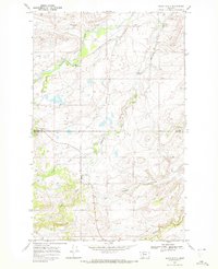
1968 Map of Heart Butte
USGS Topo · Published 1972About this map
Heart Butte sits within the Blackfeet Indian Reservation on this 1968 field-checked map, serving as a primary point of settlement where several important watercourses converge. The landscape is defined by the drainage patterns of Badger Creek and the long, winding Whitetail Creek, which carves through the central terrain. Evidence of water management for the region is seen in the inclusion of a Canal, a Feeder, and a Gaging Sta along the banks of Badger Creek. Further south, the topography is shaped by Feather Tail Coulee and the branching North Fork and South Fork, eventually reaching Blacktail Creek. The map also clearly delineates the border between Glacier Co and Pondera Co, providing a precise look at the jurisdictional and physical geography of this Montana region during the late 1960s.
Find a feature on this map
11 named features on this map. Tap any name to fly to it.
Don’t see what you’re looking for? This feature index may not catch every label — zoom into the map to look around manually.
Map Details
Editions of this 1968 Heart Butte Map
2 editions found
Other maps of this area

1914 · Heart Butte
USGS Topo · 1:125,000

1918 · Heart Butte
USGS Topo · 1:125,000

1960 · Cut Bank
USGS Topo · 1:250,000

1963 · Cut Bank
USGS Topo · 1:250,000

1964 · Cut Bank
USGS Topo · 1:250,000

1968 · Swift Reservoir
USGS Topo · 1:24,000
1968 · Piegan
USGS Topo · 1:24,000

1968 · Fish Lake
USGS Topo · 1:24,000

1968 · White Man Coulee
USGS Topo · 1:24,000
1968 · Magee Ranch
USGS Topo · 1:24,000