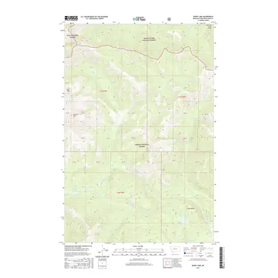
2017 Map of Heart Lake
USGS Topo · Published 2017About this map
Helena National Forest occupies the central portion of this Montana mountain landscape, where the Lewis and Clark Range defines the high terrain. The drainage systems here are complex, feeding into the E Fork N Fork Blackfoot River and the meandering Landers Fork. This high-altitude wilderness is dotted with remote alpine waters, including Heart Lake, Parker Lake, and the small Webb Lake situated in the southern half of the quadrangle. Significant topographical features like Pyramid Peak and Red Ridge rise above the drainage basins of Whitetail Cr and Crow Cr. The map reveals a protected landscape shared by three major federal jurisdictions, with the Lolo National Forest and Lewis & Clark National Forest meeting at the northern boundary, illustrating the dense concentration of managed forest lands in this part of the Rockies.
Find a feature on this map
34 named features on this map. Tap any name to fly to it.
Don’t see what you’re looking for? This feature index may not catch every label — zoom into the map to look around manually.
Map Details
Editions of this 2017 Heart Lake Map
This is the sole edition of this map. No revisions or reprints were ever made.
Other maps of this area

1903 · Coopers Lake
USGS Topo · 1:125,000

1955 · Choteau
USGS Topo · 1:250,000

1957 · Choteau
USGS Topo · 1:250,000

1958 · Choteau
USGS Topo · 1:250,000

1962 · Choteau
USGS Topo · 1:250,000

1968 · Heart Lake
USGS Topo · 1:24,000

1968 · Olson Peak
USGS Topo · 1:24,000
1968 · Stonewall Mountain
USGS Topo · 1:24,000
1968 · Caribou Peak
USGS Topo · 1:24,000
1968 · Arrastra Mountain
USGS Topo · 1:24,000