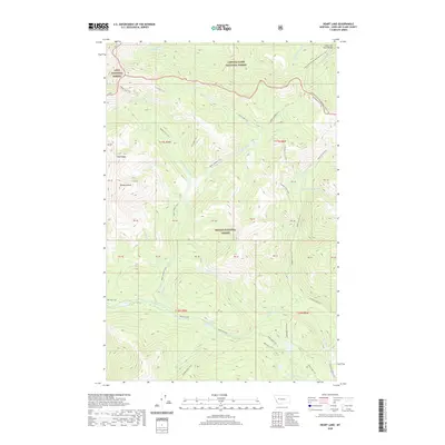
2020 Map of Heart Lake
USGS Topo · Published 2020About this map
The Lewis and Clark Range dominates this portion of the Montana Rockies, where three separate wilderness management areas converge. The Lolo National Forest, Lewis & Clark National Forest, and Helena National Forest meet in a complex landscape of high ridgelines and alpine basins. The Continental Divide National Scenic Trail winds through the northeastern corner, tracing the spine of the continent. Below these heights, a network of historic backcountry routes like the Middle Fork Trail and Upper Landers Trail provide access to isolated water bodies including Heart Lake, Webb Lake, and Two-Point Lake. The hydrology is defined by the headwaters of the E Fork N Fork Blackfoot River and the Landers Fork, which carve deep drainage patterns between prominent landmarks such as Red Ridge and Pyramid Peak.
Find a feature on this map
44 named features on this map. Tap any name to fly to it.
Don’t see what you’re looking for? This feature index may not catch every label — zoom into the map to look around manually.
Map Details
Editions of this 2020 Heart Lake Map
This is the sole edition of this map. No revisions or reprints were ever made.
Other maps of this area

1903 · Coopers Lake
USGS Topo · 1:125,000

1955 · Choteau
USGS Topo · 1:250,000

1957 · Choteau
USGS Topo · 1:250,000

1958 · Choteau
USGS Topo · 1:250,000

1962 · Choteau
USGS Topo · 1:250,000

1968 · Heart Lake
USGS Topo · 1:24,000

1968 · Olson Peak
USGS Topo · 1:24,000
1968 · Stonewall Mountain
USGS Topo · 1:24,000
1968 · Caribou Peak
USGS Topo · 1:24,000
1968 · Arrastra Mountain
USGS Topo · 1:24,000