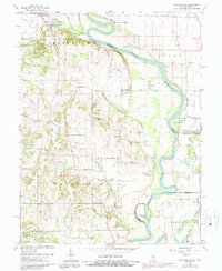
1964 Map of Heathsville
USGS Topo · Published 1989About this map
The Wabash River carves a sinuous path through this riverine landscape, defining the Illinois-Indiana border between Crawford County and Sullivan County. This 1960s survey illustrates a region shaped by both agricultural drainage and industrial extraction, with Oil Wells, a Gas Well, and a Gravel Pit interspersed among the bottomlands. The map preserves several family-named landmarks and historical community centers, such as Heathsville and Richwoods, alongside notable archaeological features like the Indian Mound near Bristol Hill.
Find a feature on this map
52 named features on this map. Tap any name to fly to it.
Don’t see what you’re looking for? This feature index may not catch every label — zoom into the map to look around manually.
Map Details
Editions of this 1964 Heathsville Map
3 editions found
Other maps of this area

1917 · Birds
USGS Topo · 1:62,500

1942 · Birds
USGS Topo · 1:62,500

1943 · Merom
USGS Topo · 1:24,000

1943 · Carlisle
USGS Topo · 1:24,000

1943 · Oaktown
USGS Topo · 1:24,000

1943 · Sullivan
USGS Topo · 1:24,000

1953 · Indianapolis
USGS Topo · 1:250,000

1956 · Indianapolis
USGS Topo · 1:250,000
1956 · Sullivan
USGS Topo · 1:24,000

1956 · Vincennes
USGS Topo · 1:250,000