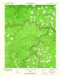
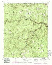
1943 Map of Hebbertsburg
USGS Topo · Published 1966About this map
Hebbertsburg and Frankfort anchor this 1940s landscape where the Obed River carves a winding path through the borderlands of Morgan and Cumberland counties. The map captures a rural network of community life before modern infrastructure, marked by the presence of local centers like Potter Chapel Sch and Frankfort Sch. Significant topographic prominence is found at Pilot Knob, topped by the Pilot Knob Lookout Tower, providing a strategic view over Peavine Mountain and Hawn Ridge.
Find a feature on this map
51 named features on this map. Tap any name to fly to it.
Don’t see what you’re looking for? This feature index may not catch every label — zoom into the map to look around manually.
Map Details
Editions of this 1943 Hebbertsburg Map
5 editions found
Other maps of this area

1887 · Kingston
USGS Topo · 1:125,000

1891 · Kingston
USGS Topo · 1:125,000

1893 · Kingston
USGS Topo · 1:125,000

1895 · Wartburg
USGS Topo · 1:125,000

1896 · Wartburg
USGS Topo · 1:125,000

1935 · Lancing
USGS Topo · 1:24,000

1935 · Pilot Mountain
USGS Topo · 1:24,000

1936 · Hebbertsburg
USGS Topo · 1:24,000

1936 · Fox Creek
USGS Topo · 1:24,000

1936 · Twin Bridges
USGS Topo · 1:24,000