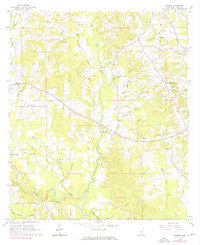
1965 Map of Hebron
USGS Topo · Published 1976About this map
Mt William Ch and Harper Cem anchor a rural landscape in Jones County defined by the winding course of Big Creek and its many tributaries. The settlement of Hebron sits near the western edge of the quadrangle, while the southern reaches are dominated by the wide bends of the Leaf River. The map reveals a community structured around its spiritual centers, with several country churches including Duck Hill Ch, Sweet Beulah Ch, and Morning Star Ch serving as primary landmarks across the rolling terrain. Industrial activity is minimal but visible at the Claypit near the center of the sheet, while natural features like Horseshoe Lake and Oakey Woods Creek highlight the swampy bottomlands near the river. This mid-century survey captures the region's transition into the modern era, showing established rural homesteads connected by a network of developing roads and pipelines.
Find a feature on this map
31 named features on this map. Tap any name to fly to it.
Don’t see what you’re looking for? This feature index may not catch every label — zoom into the map to look around manually.
Map Details
Editions of this 1965 Hebron Map
3 editions found
Other maps of this area

1953 · Hattiesburg
USGS Topo · 1:250,000

1958 · Hattiesburg
USGS Topo · 1:250,000

1964 · Moss
USGS Topo · 1:24,000

1964 · Laurel West
USGS Topo · 1:24,000

1964 · Seminary
USGS Topo · 1:24,000

1964 · Ellisville
USGS Topo · 1:24,000

1965 · Hebron
USGS Topo · 1:24,000

1965 · Hot Coffee
USGS Topo · 1:24,000

1965 · Moselle
USGS Topo · 1:24,000

1974 · Soso
USGS Topo · 1:24,000